Rio Mameyes
Puerto Rico
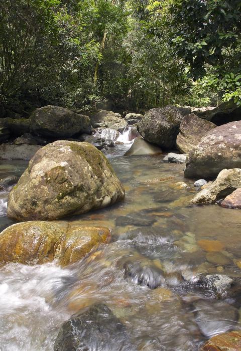
The Rio Mameyes originates in the upper elevations of the El Yunque National Forest at over 2,000 feet in a cloud forest and flows from there in a northernly direction. The river is bounded by steep, rugged slopes throughout its length with large boulders along the shore and within the stream which makes for many cascades and small waterfalls. The lush and varied vegetation found along the banks provide a very picturesque setting.
The Rio Mameyes watershed covers 6.88-square miles within the El Yunque National Forest, or 10.4% of the forest. Water quality is optimum within the upper segment since the entire corridor is located in the Baño de Oro Natural Area and no development exists. Due to steep slopes, no significant flood plains occur. There are approximately 73 acres of riparian wetlands in the designated segments.
Designated Reach
December 19, 2002. From its headwaters in the Ban.AE6o de Oro Research Natural Area to the boundary of the Caribbean National Forest.
Outstandingly Remarkable Values
Botany
The tropical moist forests of Puerto Rico are characterized for their great diversity of plants, although somewhat less so than in continental tropical forests. More tree species occur on the El Yunque than in all the other 155 national forests combined, and none of these species occur on any other national forest. Nearly one-third of the forest’s tree species are endemic to Puerto Rico, and 10% are endemic to the forest itself.
The Rio Mameyes corridor within the forest contains five ecological life zones—subtropical wet forest, subtropical rain forest, lower montane wet forest, lower montane rain forest, and a small area of subtropical moist forest. Its vegetation includes four major forest types—Tabonuco, Palo Colorado, Sierra Palm, and Cloud Forest.
The core of the forest remains in primary condition without significant human modification. This primary forest is the largest remnant of the original forest that covered virtually the entire island at the time of Columbus’ arrival more than 500 years ago. The primary forest presents a unique window to the past and a natural control against which past, and ongoing changes, in Puerto Rico’s and other tropical forests, can be measured. It provides the only currently suitable habitat for many endemic plant species.
Geology
Elevation on the forest ranges from 100 feet at the northern boundary to 3,533 feet at El Toro Peak. Terrain ranges from gentle slopes in low elevations to rugged side slopes exceeding 60% in higher elevations, where vertical rock-faced cliffs are numerous. On the forest’s north slopes, the Rio Mameyes drops rapidly at high elevations and more gradually below. Geologic parent materials are of three basic types—marine-deposited Cretaceous volcanic rocks, the most widespread; tertiary intrusive quartz diorites on the south side of the forest; and quaternary unconsolidated alluvial deposits (sand, gravels, silts, and clays) along major water courses.
Recreation
The major recreational experiences are passive enjoyment of the natural environment, picnicking, wading in the water, and hiking. Currents within the rivers are generally conducive to water play. The river is relatively shallow and has easy access between the rocks and along the banks. The large boulders make the stream a good place for sitting and cooling off. Recreation tends to be family activity oriented. Most of the river corridor is primitive with minimal human activity. Bird watching and nature photography are also very popular along the river corridors. The Puente Roto area, found along the recreation segment of the Rio Mameyes, has a large area for water play due to the river’s width at this point. The area is used as an undeveloped recreation area, but visitors enjoy wading in the water, relaxing on boulders, and picnicking along the banks of the river.
There are two trails (Carillo and Bisley Trail) found along the scenic corridor of the Rio Mameyes. Both trails are primitive and are rarely used because of their challenging conditions and the little to no maintenance they receive.
Scenery
The river has a moderate to steep gradient and rapid/pool flow characteristics with many cascades and small waterfalls. The swales are steep and wide with extensive exposed bedrock. The streambed is rocky with numerous large boulders. The recreation segments of the Rio Mameyes, from Angelito Trail to Puente Roto, have various wading pools which are surrounded with large boulders. The riverbanks are lined with large native trees, as well as tree ferns and palms.
Wildlife
The fauna that is found along the river corridor is one of the most distinguishable communities in Puerto Rico. Species exhibit traits unique only to tropical ecosystems. Aquatic, bird, and terrestrial animal species on the forest have many distinct characteristics that have evolved through interactions that promote specialization. The range of species includes over 127 terrestrial vertebrates, 77 bird species, and 17 freshwater fish species. The El Yunque boasts a spectacular degree of biodiversity in comparison to other national forests. Wildlife can be observed and photographed in the treetops, along the shoreline, and in the water of the Rio Mameyes.

