Rio Chama
New Mexico
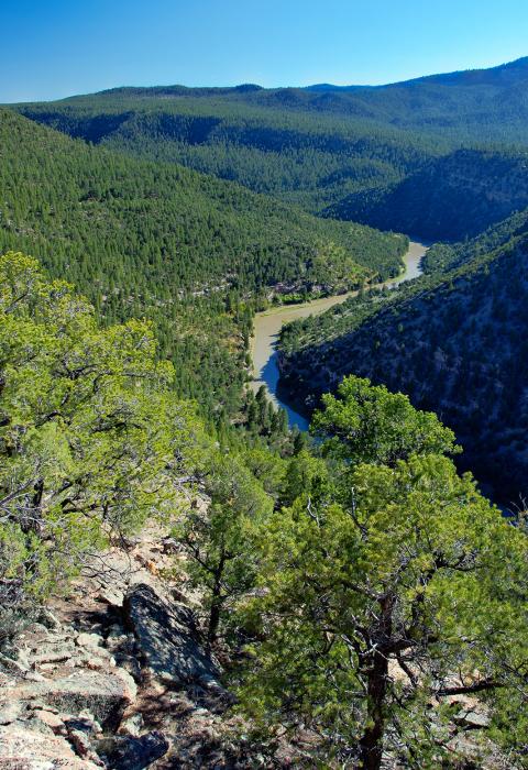
The Rio Chama is a major tributary of the Rio Grande in northern New Mexico. It flows through a multi-colored sandstone canyon which is, at times, 1,500 feet deep and through a wilderness and wilderness study area. Towering cliffs, heavily wooded side canyons, and historical sites offer an outstanding wild river backdrop for the hiker, fisherman, or boater.
Car camping is popular on the lower eight miles, and boaters enjoy can two- or three-day trips on Class II and III rapids on the entire 31-mile segment* (advance permits required), or half day trips on the lower segment (no advance permits required).
Co-managed by the Bureau of Land Management and the U.S. Forest Service, the Rio Chama offers something for everyone—paddling, trout fishing, hiking, exploring dinosaur tracks, and simply relaxing in the shade. Applications for boating permits in the upper canyon can be obtained through Recreation.gov. Applications for the lottery must be received by February 1 of each year.
*The first 24.6 miles are designated as a wild and scenic river; the lower section is a congressional study river for possible designation.


Designated Reach
November 7, 1988. From El Vado Ranch launch site (immediately south of El Vado Dam) downstream 24.6 miles.
Outstandingly Remarkable Values
Geology
The Rio Chama carved a 900-foot-deep canyon of colorful siltstone, gypsum, and sandstone layers. Floating down the river provides an ever-changing view of sedimentary layers traveling back in time millions of years. There are even the imprints of dinosaur tracks preserved in one side canyon.
Prehistory
Northern New Mexico, and the Rio Chama Valley in particular, are known as some of the richest regions for archeology studies in the U.S. For more than three centuries—about A.D. 1250 to 1577—this spectacular locale was home for over 1500 Pueblo Indians who built villages, dwelled, farmed, and hun...Show More
Recreation
Water releases from the upstream El Vado Lake Dam are often timed to allow weekend river floats from below El Vado Reservoir to Big Eddy. To protect the river environment and to maintain an opportunity for a high-quality experience, use is limited through a lottery system. Several hiking trails a...Show More
Scenery
The Rio Chama creates a canyon of colorful siltstone and sandstone surrounded by gently rolling sagebrush-covered plains. Piñon woodlands cover the hills, and forests of ponderosa pine and Douglas fir cover the north-facing slopes.
Wildlife
Trout often flourish in the river, and onshore residents include mule deer, black bears, elk, coyotes, and mountain lions. Varying canyon elevations also provide a wide range of vegetation, from low-lying pinion-juniper woodland to ponderosa pine and fir. Between 70 and 80 different bird varietie...Show More