Delaware (Lower) River
Delaware (Lower) River
New Jersey, Pennsylvania
The lower Delaware River possesses a great diversity of significant resources. A high density of population and recreational opportunities combine with a wealth of natural, cultural, and historic features of national significance. The river valley contains habitats that do not occur elsewhere in the region. For example, there are sheer cliffs that rise 400 feet above the river. Southern facing cliffs are desert-like and home to prickly pear cactus. North-facing cliffs exhibit flora and fauna usually found only in arctic-alpine climates. The river itself provides habitat for American shad, striped bass, and river herring. The river is an important component of the Atlantic Flyway, one of four major waterfowl routes in North America. From an historic viewpoint, the river is one of the most significant corridors in the nation. The corridor contains buildings used during Washington's famous crossing, historic navigation canals, Native American and colonial era archaeological sites, and mills.
Designated Reach
November 1, 2000. Several segments of the Delaware River and its tributaries: 1) from river mile 193.8 to the northern border of the city of Easton, Pennsylvania; 2) from just south of the Gilbert Generating Station to just north of the Point Pleasant Pumping Station; 3) from just south of the Point Pleasant Pumping Station to a point 1,000 feet north of the Route 202 Bridge; 4) from 1,750 feet south of the Route 202 Bridge to the southern boundary of the town of New Hope, Pennsylvania, to the town of Washington Crossing, Pennsylvania; 5) all of Tinicum Creek; 6) Tohickon Creek from the Lake Nockamixon Dam to the Delaware River; and 7) Paunacussing Creek in Solebury Township.
Outstandingly Remarkable Values
Culture
Sites along the lower Delaware River and its tributaries indicate early American Indian use of the river for habitation. The southern terminus of the Lower Delaware segment includes the Washington Crossing historic site. New Hope is significant not only for its association with the Delaware Canal, but also because artists residing and working there and in the vicinity formed the nucleus of the New Hope School of painting.
Ecology
The lower Delaware River segment provides the transition through the Ridge and Valley, New England, and Piedmont provinces and encompasses many transition zones for the Delaware River. A unifying feature throughout the full extent of the lower Delaware River is the broad and complete assemblage of migratory fish. Island habitats are common and significant for their numbers, acreages, and diversity of species. The lower Delaware supports areas of natural riparian corridors and their characteristic flora and fauna and a diverse assemblage of native warm water fish. The river’s important position along the Atlantic flyway is evident in supporting foraging and breeding habitat for rare water-dependent bird species.
Geology
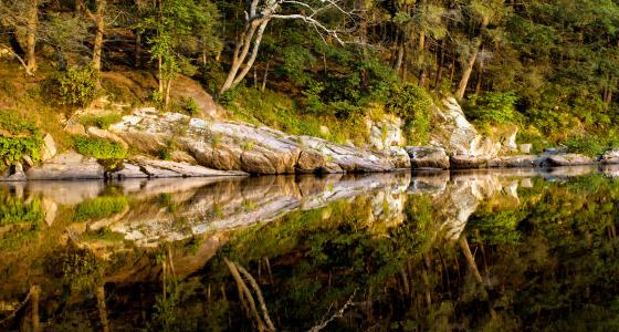
The lower Delaware River is shaped by the varied geology through which it has carved its way to the Atlantic Ocean. At the northern end of the Lower Delaware River, it cuts through folded ridge and valley formations created by colliding tectonic plates and the uprising of the modern Appalachian Mountains. The hydro-geomorphology of the river is characterized by riffle/pools, deep runs, and huge glacial boulders, rapids, and ledges.
Recreation
The range of active and passive recreational experiences is enhanced because visitors and residents alike can access the river corridor through a wide range of travel options. There are 28 state and locally managed access points along the approximately 70 miles of the lower Delaware River mainstem between the Delaware Water Gap and Washington Crossing State Park in New Jersey. Various challenges are available for boaters with different levels of experience, from Class I slow-moving waters suitable for beginners, such as Upper Black Eddy, to Class II rapids like those at Foul Rift and the Lambertville wing dam for more experienced boaters.
Scenery
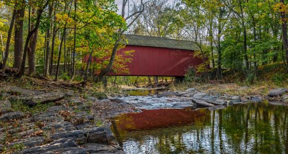
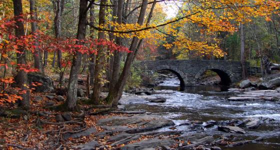
The lower Delaware River corridor is recognized for its unique diversity of scenic resources that are accessible by road, river, trail, and canal. Narrow roads, some of which are designated scenic byways, parallel the entire Lower Delaware River corridor. Particularly notable are the forested islands, the renowned rock features of cliffs and falls, tumbling streams, steep ravines, and spectacular seasonal foliage. Dramatic features include, but are not limited to, Milford Bluffs, Devil’s Tea Table, Tumble Falls, Nockamixon Cliffs, and Cuttalossa Falls.